
You can find on this page the map of London suburban train, the map of London overground, the map of London DLR, the map of London Crossrail, the map of the South West Trains, the map of the First Capital Connect, the map of the Southern Railway, the map of the C2C, the map of the First Great Western, the map of the Chiltern Railways, the map of the Abellio Greater Anglia, the map of the Southeastern Railway and the map of the Heathrow Connect. These 12 urban, suburban and communter train networks are a transit system serving the city of London (United Kingdom) with the tube, the tram, the bus, the nigth bus or the river bus. These 12 commuter train networks have 52 lines and 1,325 stations forming a rail network of 2,671 miles (4,300 km).
The metro train network serves Greater London and the surrounding areas of Essex, Hertfordshire and Buckinghamshire. It is commonly referred to as "Underground" although 55% of the network is above ground or "The Tube". The Metropolitan Railway is the first line, inaugurated on January 10, 18632, making it the oldest metropolitan network in the world. Many rail transport networks coexist in London. We are going to present them to you on this page as well as the various associated plans.

The London urban, suburban and communter trains network is gathering several train networks.
Its network includes the following 12 networks:
In addition to the London Underground, suburban trains, owned by several companies, serve the city from end to end through the centre. Twelve urban trains form one of London's public transport systems: DLR, Crossrail, South West Train, C2C, First Great Western, Chiltern Railways, Abelio Greater Anglia, Southeastern Railway and Heathrow Connect. The commuter trains consist of 52 lines including 1325 stations forming a network of more than 4300 km.
If you want to reach the city from East to West or North to South, the suburban train is the fastest means of transport. There are many stations and you will always find one not too far from your destination.
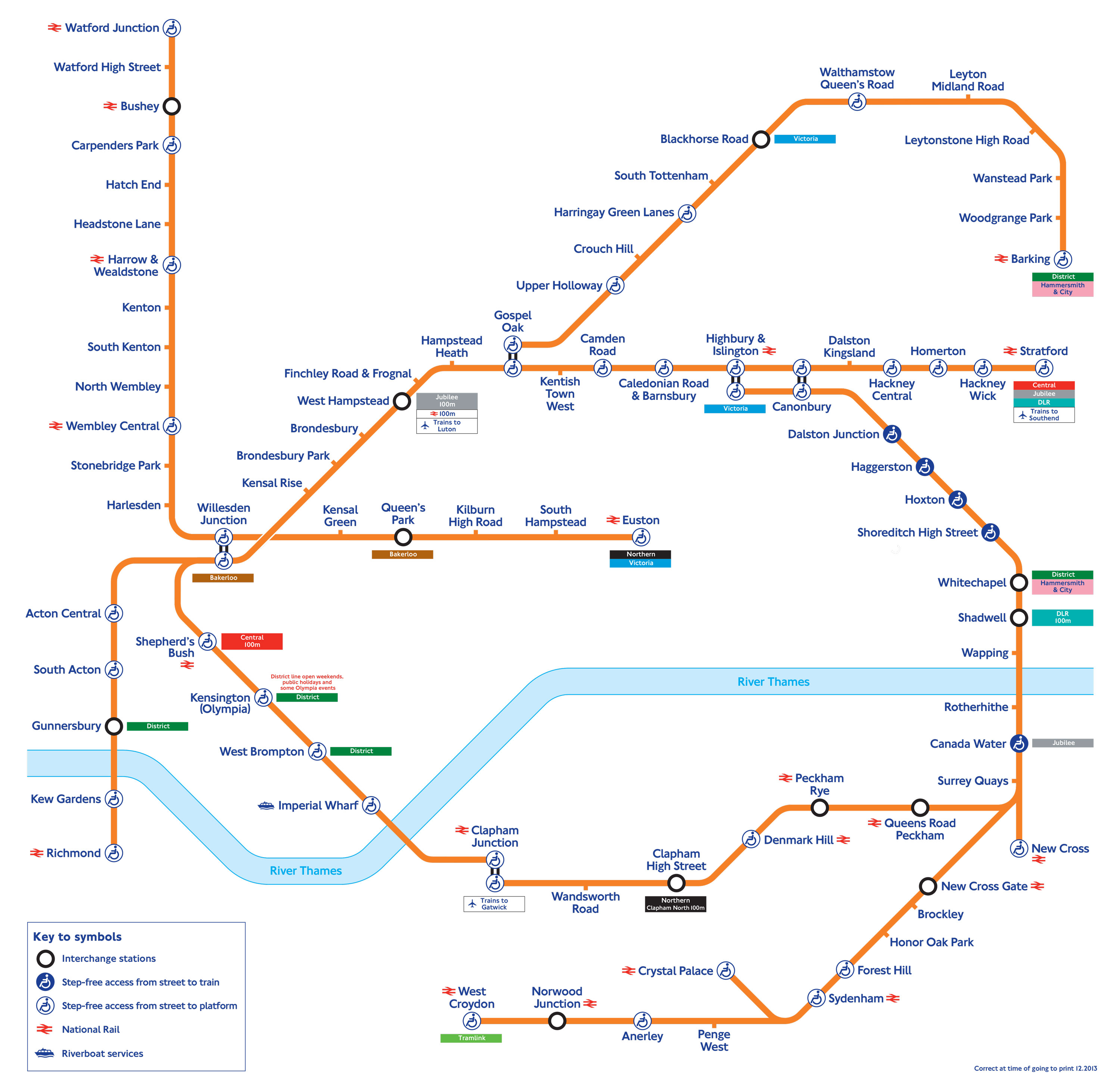
The London Overground which transports 124.6 million passengers per year, exists since 2007 and is operated by the TFL (Transport for London). Its network of 84 stations and 53 miles (86 km) includes 6 lines.
The London Overground is a suburban rail network serving the Greater London area. The London Overground covers Greater London and Hertfordshire. It has 6 main links:
Fares are the same as for other means of transport. You can use your OysterCard on all London Overground lines within zones 1 and 9. The London Overground is connected to some underground and bus lines and is easily recognised by its orange colour on London transport maps.
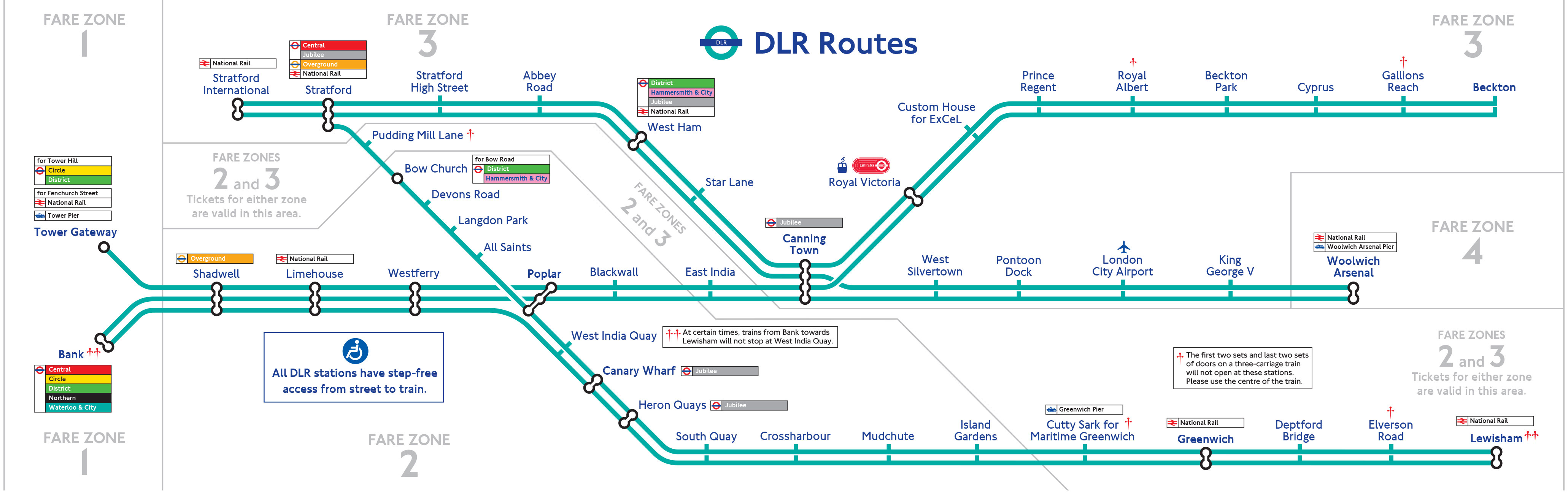
The Docklands Light Railway (DLR) which transports 100 million passengers per year, exists since 1987 and is operated by the TFL (Transport for London).
Its network of 45 stations and 21 miles (34 km) includes the following 7 lines:
The Docklands Light Railway is part of the Greater London public rail network. It is a network of mainly aerial (the view can be very beautiful) self-drive trains serving the East End of the city, including the docklands area along the Thames (Canary Wharf, Cutty Sark, Royal Greenwich observatory, Greenwich Market, Greenwich Park, Greenwich Meridian...).
All DLR lines are accessible to people with reduced mobility, DLR stations are equipped with lifts and the ramps to the platform are at the same level as the train.
The Docklands Light Railway is connected to the London Underground, Buses, Emirates Air Line and mainline railways.
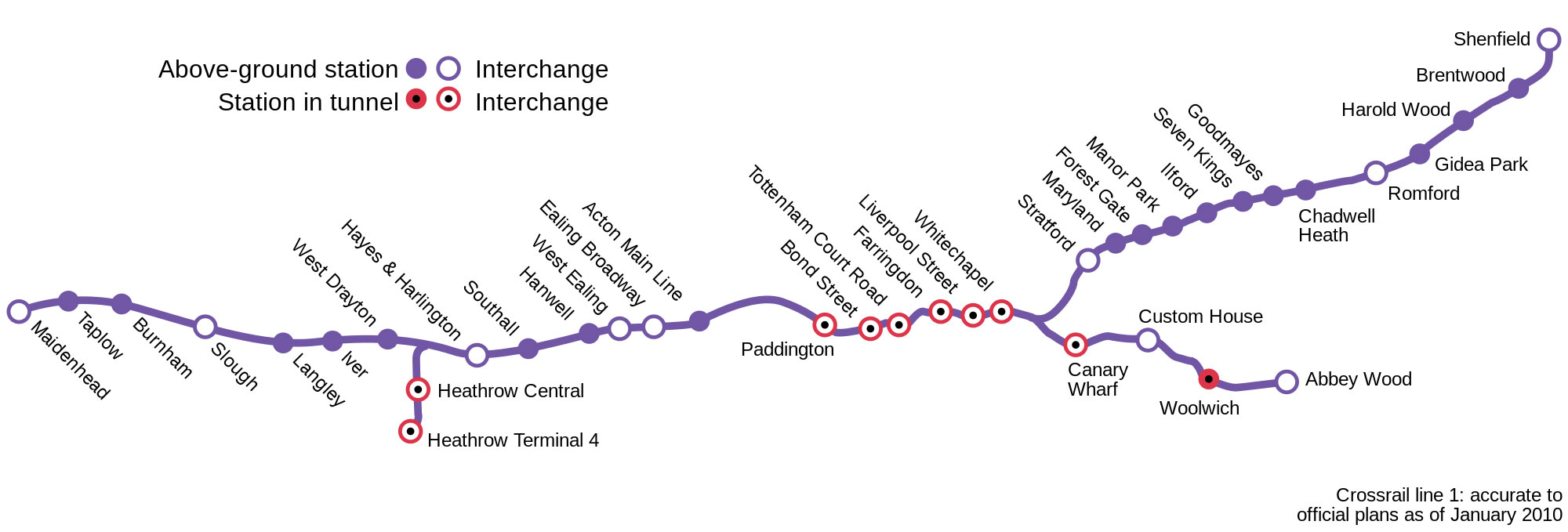
The Crossrail, an urban & suburban train in construction, will open in 2015 and will be operated by the TFL (Transport for London).
Its network of 40 stations and 85 miles (136 km) includes the following 2 lines:
The Crossrail is a rail network serving Greater London. The network consists of three X-shaped lines in central London. The Crossrail is also known as the Elizabeth Line.
The first line of the Crossrail is intended to link Reading Station, west of the British capital, to Shenfield Station on the left bank of the Thames, and Abbey Wood Station on the right bank of the river. 11 London Underground stations will be served: Ealing Broadway, Paddington, Liverpool Street, Whitechapel, Stratford, Canary Wharf or Custom House.
A branch line will also serve two London Heathrow Airport stations (Heathrow terminals 1, 2, 3 and Heathrow terminal 4). Liverpool Street station will also be connected to Moorgate.
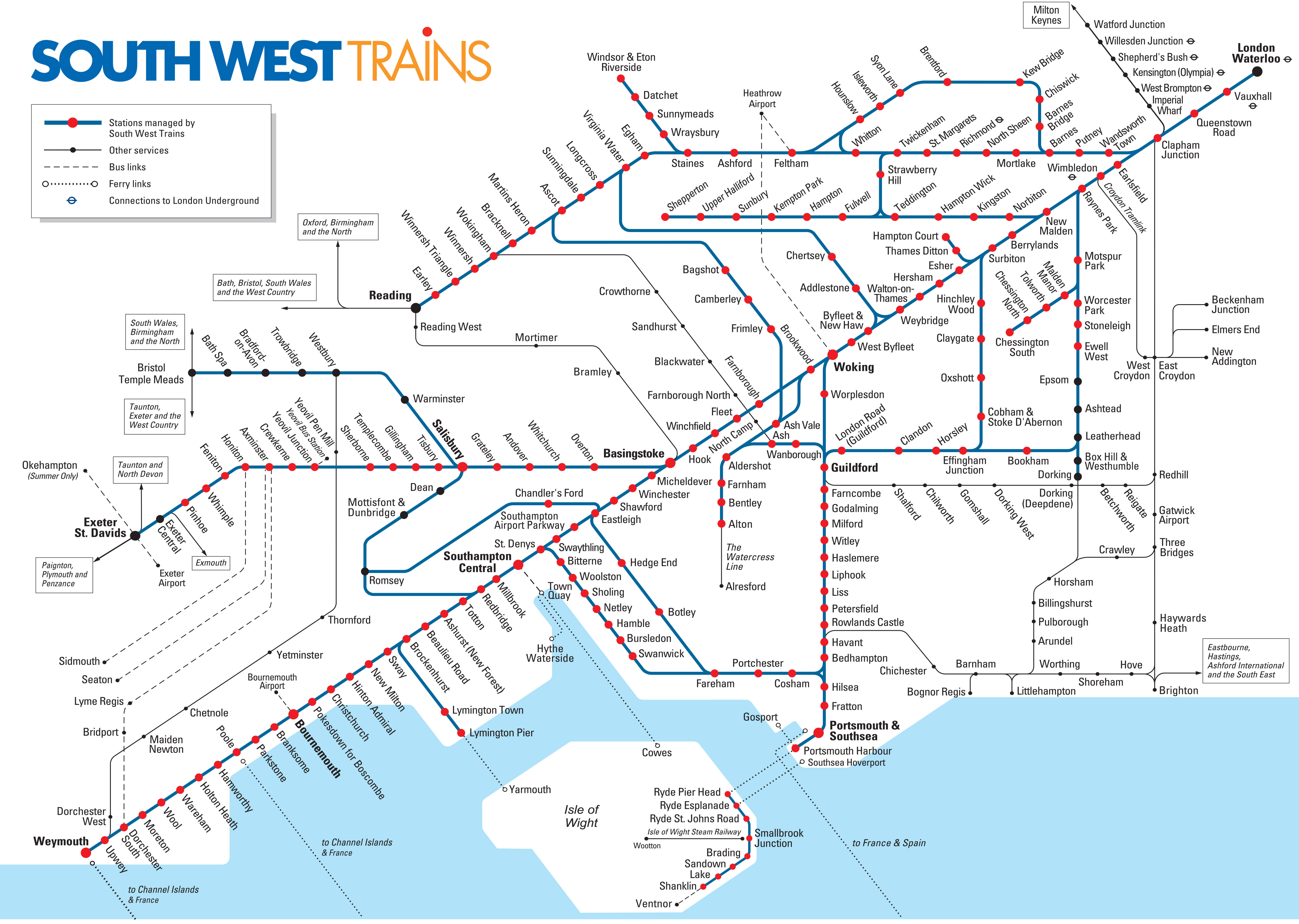
Le South West Trains est la franchise South Western depuis 2007 et est exploité par Stagecoach. Son réseau se compose de 213 stations.
South Western Railway (SWR) is a UK rail operating company that operates the South Western franchise. It operates commuter train services from its central London terminus (London Waterloo) to south-west London. SWR was awarded the South Western franchise in March 2017 and took over from South West Trains on 20 August 2017.
South West Trains was a British railway company that operated the South Western franchise between 1996 and 2017.
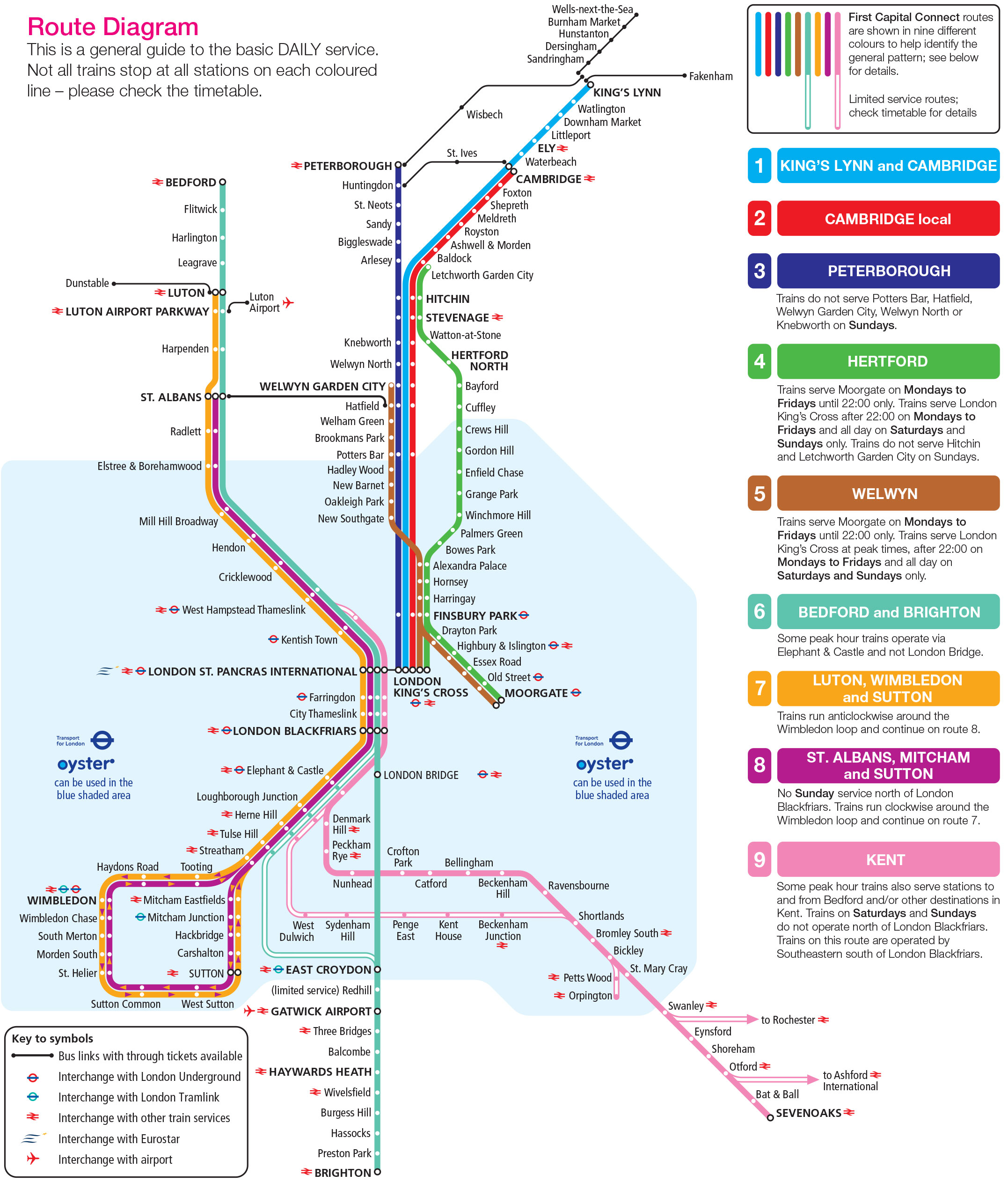
The First Capital Connect which transports 3.2 billion passengers per year, is the Thameslink Great Northern franchise since 2006 and is operated by First Group.
Its network of 77 stations and 485 miles (779 km) includes the following 9 lines:
First Capital Connect is a railway company created on 1 April 2006 following the takeover of the wagn (West Anglia Great Northern Railway) and Thameslink franchises.
First Capital Connect ceased operations on 14 September 2014. First Capital Connect was acquired by Govia Thameslink Railway and became part of the Thameslink franchise.
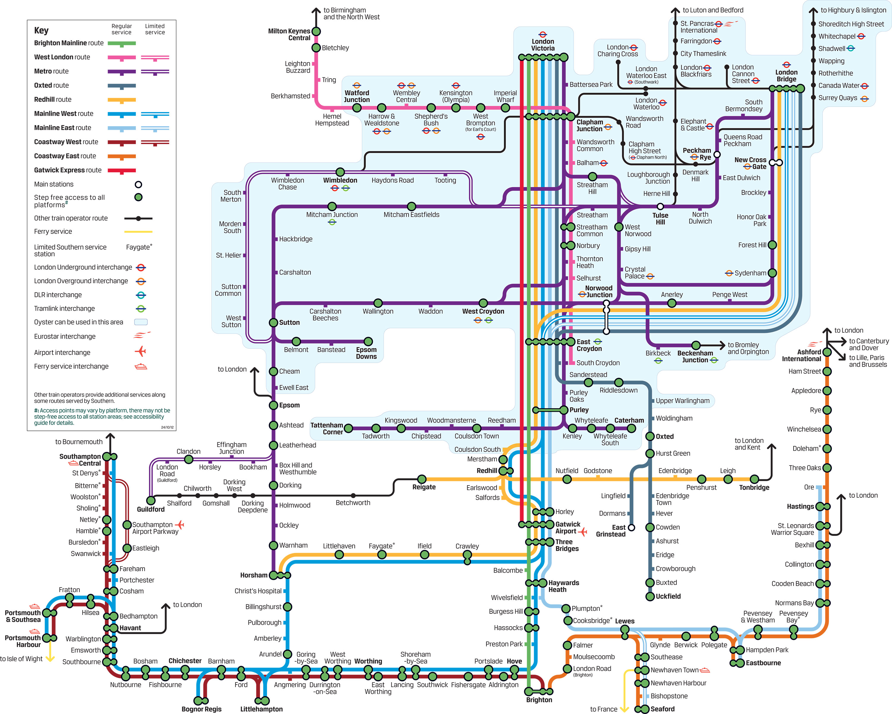
The Southern Railway is the Network SouthCentral franchise since 2009 and is operated by Govia (Go-Ahead and Keolis).
Its network of 179 stations includes the following 10 lines:
The Southern Railway network consists of commuter rail lines in South London and regional services extending into the southern counties.
All Southern Railway lines are south of the Thames, with the exception of the West London line which runs through London via Shepherd's Bush and up the West Coast main line to Milton Keynes.
Together with the Thameslink Railway and the Crossrail line, it is one of the few long-distance national lines to cross London instead of stopping at one of London's railway terminals. Southern lines that do not serve London include the West Coastway and East Coastway lines along the south coast of Sussex, Kent and Hampshire.
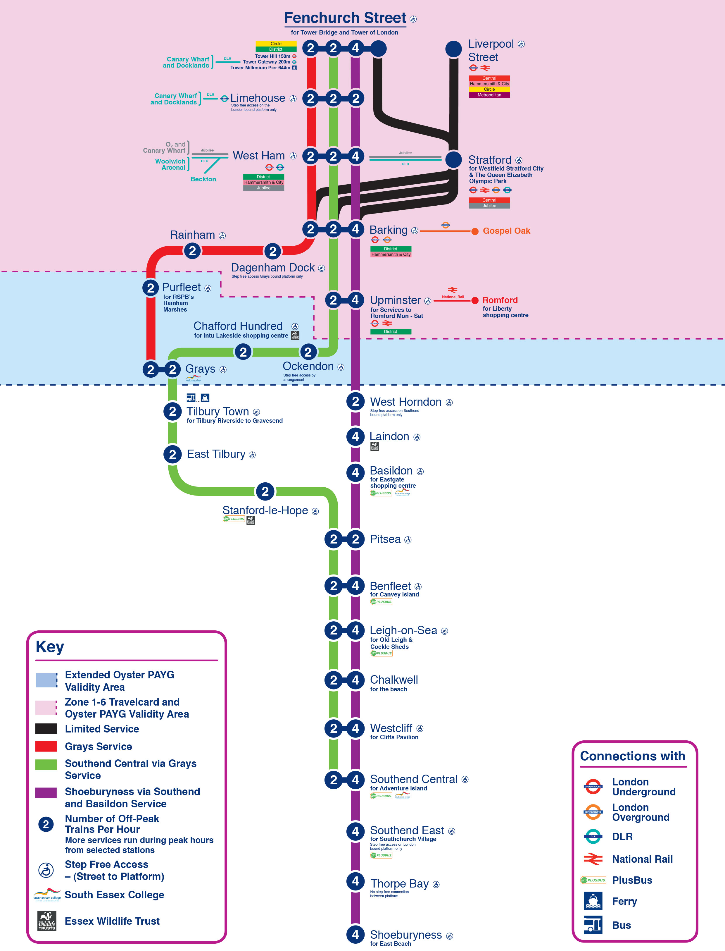
The C2C which transports 916 million passengers per year, is the Essex Thameside franchise since 1996 and is operated by National Express.
Its network of 28 stations and 80 miles (129 km) includes the following 3 lines:
Trenitalia c2c Limited (known as c2c) is an English train operating company owned by Trenitalia which operates the Essex Thameside railway franchise. C2C operates 25 stations and provides suburban services from its London terminus Fenchurch Street and from Liverpool Street to East London.
In May 1996 the company was established as LTS Rail. Its owner, Prism Rail, had obtained the London rail franchise, Tilbury & Southend, as part of the privatisation of British Rail. LTS Rail was renamed c2c in May 2000 and Prism Rail was acquired by National Express in the same year. National Express then sold c2c to the Italian operator Trenitalia in February 2017.
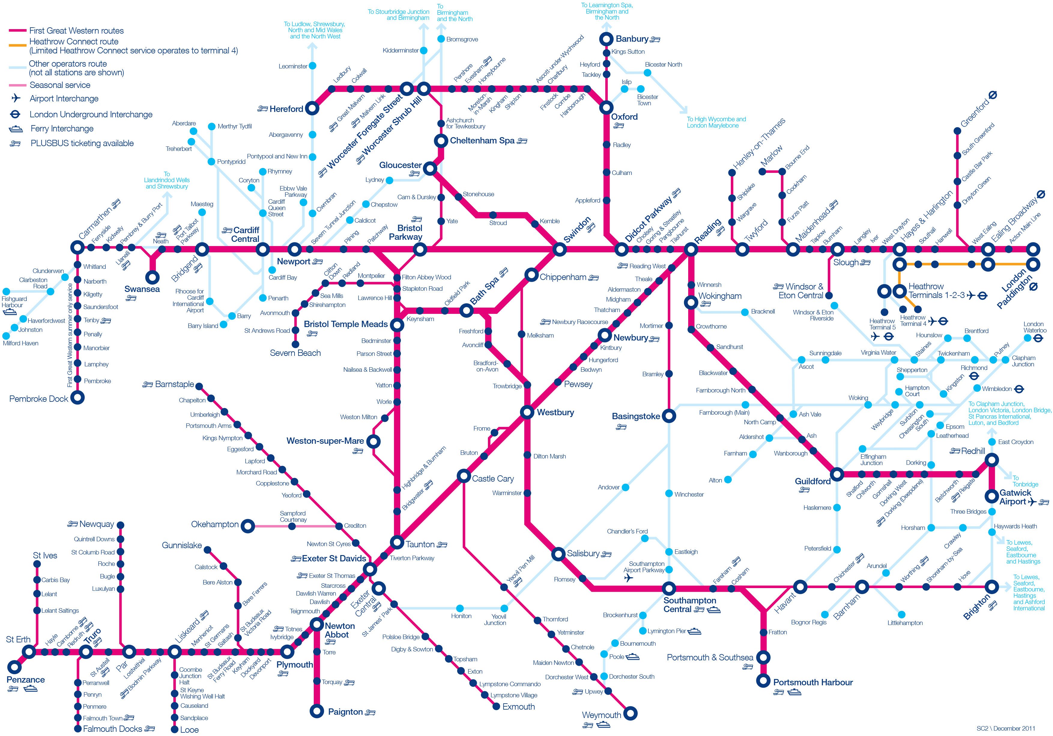
The First Great Western which transports 4.9 billion passengers per year, is the Great Western franchise since 1998 and is operated by First Group. Its network includes 208 stations and 1,322 miles (2 129 km).
The Great Western Railway (GWR) is a British railway company belonging to the FirstGroup Plc group. GWR operates the Great Western Main Line network.
The Great Western Railway's rail network comprises three main routes to the south-west of England and south Wales, departing from London-Paddington station :
First Great Western was also awarded the concession for the Thames Valley rail network, known as the First Great Western Link, previously operated by Thames Trains.
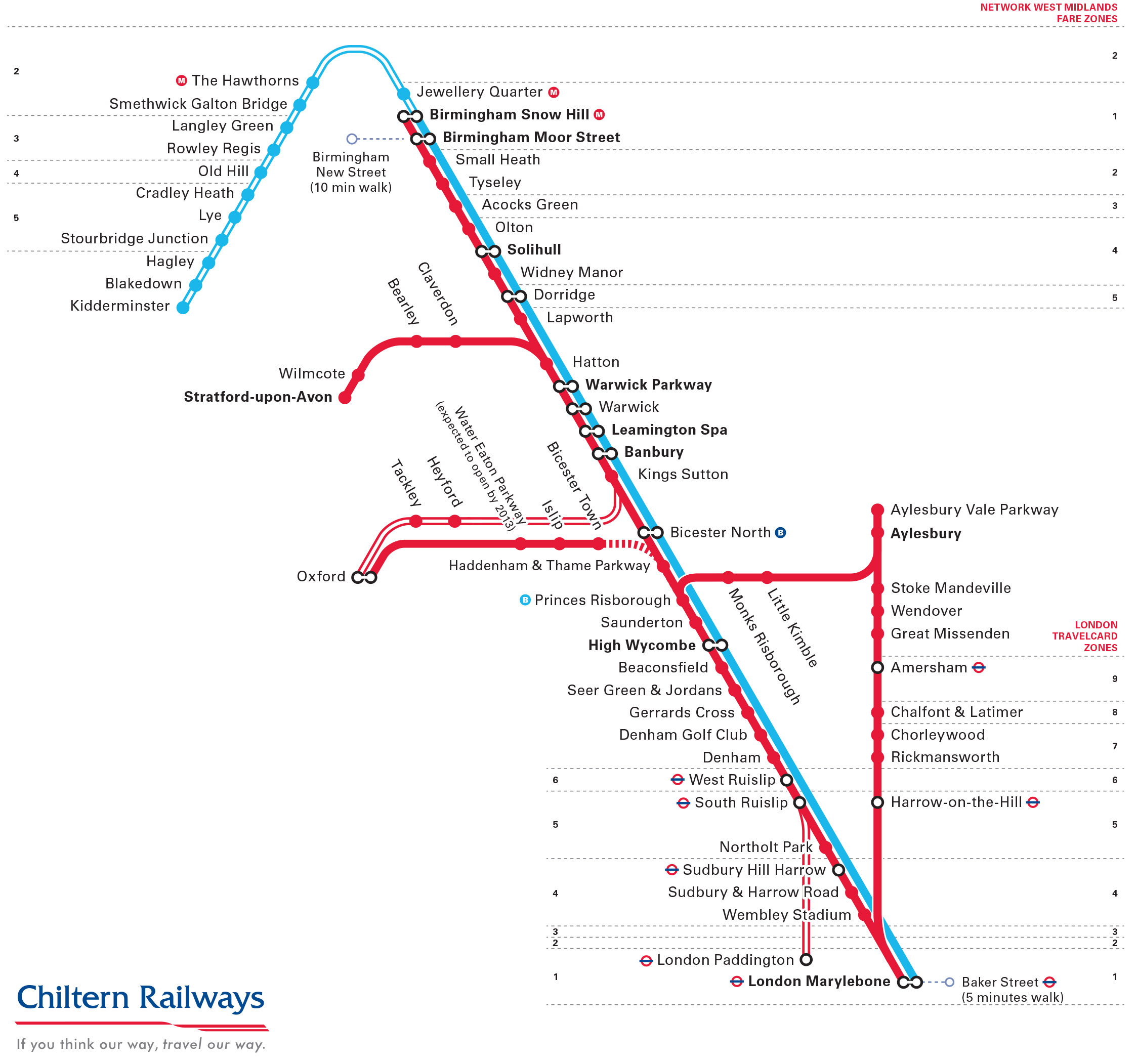
The Chiltern Railways which transports 897 million passengers per year, is the Chiltern Railways franchise since 2002 and is operated by Arriva UK Trains.
Its network of 62 stations and 208 miles (336 km) includes the following 2 lines:
Chiltern Railways is a British railway company created when British Rail was privatised in 1996. Chiltern Railways operates mainline rail services from Marylebone station in London to Aylesbury and Birmingham Snow Hill.
Since 2003 Chiltern Railways has become a wholly owned subsidiary of Laing Rail. Since 2007, Chiltern Railways has been owned by DB Regio, which in 2011 became a subsidiary of Arriva (Deutsche Bahn Group).
According to the Strategic Rail Authority, it is the 5th most punctual railway company.

The Abellio Greater Anglia is the Greater Anglia franchise since 2012 and is operated by Abellio. Its network includes 168 stations.
Greater Anglia (Abellio East Anglia Limited) is a train operating company in Great Britain. Greater Anglia is owned by Abellio (Dutch railway operator) and the Japanese trading company Mitsui & Co.
Greater Anglia operates the East Anglia franchise, providing the majority of commuter and regional train services from the central London terminus at Liverpool Street. The line serves Essex, Suffolk, Norfolk and parts of Hertfordshire and Cambridgeshire.
In May 2015, most of Greater Anglia's commuter trains were transferred to London Overground and TfL Rail. The franchise was re-tendered as East Anglia and awarded to Abellio in August 2016. In 2017, Abellio agreed to sell 40% of its shares to Mitsui.
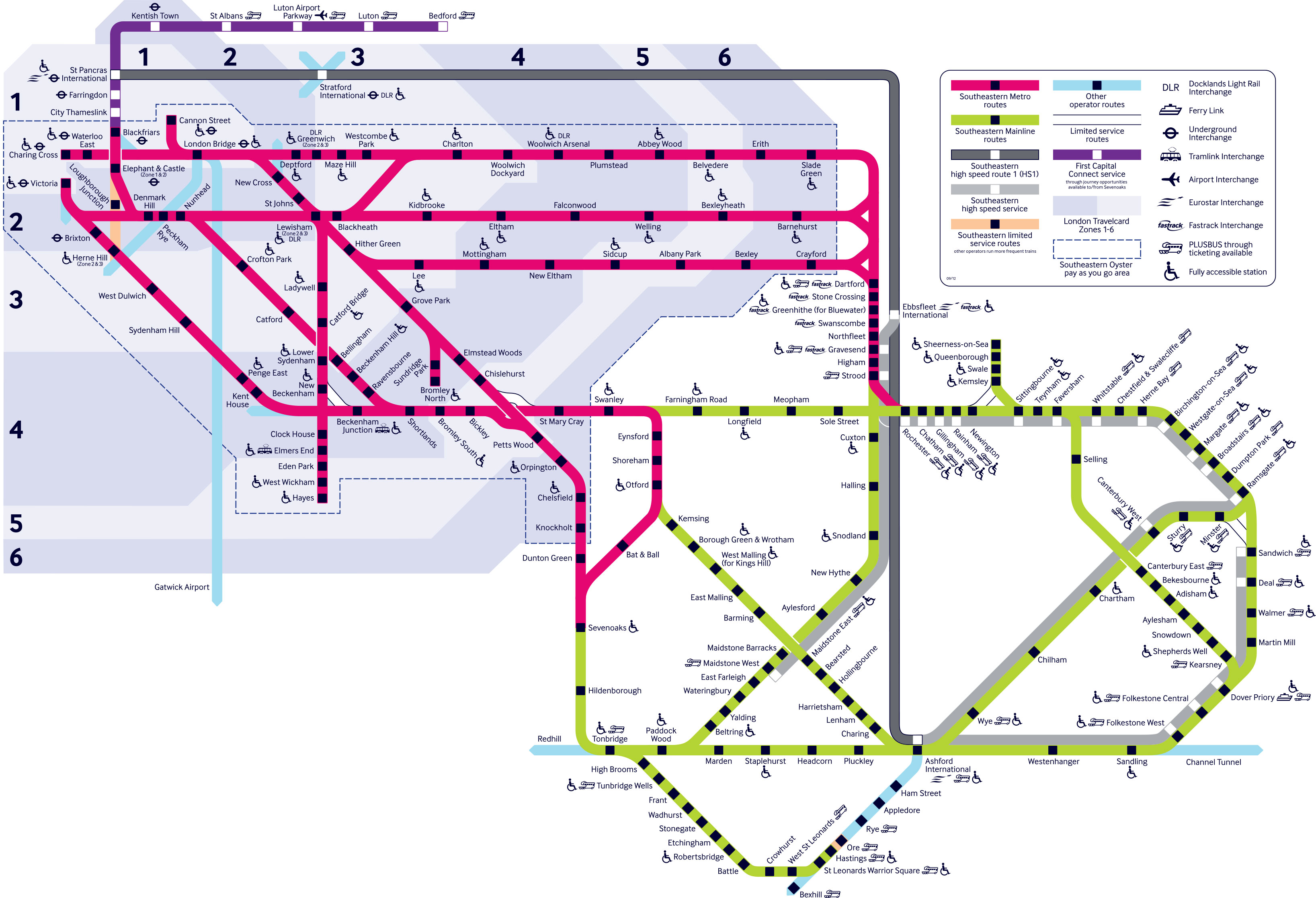
The Souteastern Railway is the Integrated Kent franchise since 2006 and is operated by Govia (Go-Ahead and Keolis)
Its network of 179 stations includes the following 14 lines:
The London & South Eastern Railway Limited (known as the Southeastern Raiway) is a British company operating trains in the south-east of England, owned by Govia (Go-Ahead Group and Keolis). Southeastern Raiway is the main operator of commuter and regional trains in South East London and Kent.
Southeastern trains run on three main lines :
The Southeastern rail network consists of 540km and 179 stations. 70% of its services are to and from London.

Heathrow Connect is an urban train line linking Heathrow Airport to central London existing since 2005 and operated by First Great Western.
Heathrow Connect was a railway company in London linking London Heathrow Airport and Paddington Station.
Heathrow Connect was on the same line as the Heathrow Express but serving intermediate stations. This provided connections between West London towns, the airport and central London (Central London). Heathrow Connect is replaced in 2018 by the "Elizabeth line". (TfL Rail).


