

You can find on this page the map of London airport transportation, the map of London Heathrow airport, the map of London Gatwick airport, the map of London Stansted airport, the map of London Luton airport, the map of London City airport and the map of London Southend airport. London is served by 6 international airports totaling more than 139.5 million passengers per year, London Heathrow (LHR), London Gatwick (LGW), London Stansted (STN), London Luton (LTN) London City (LCY), London Southend (SEN), each operated by a different company.
Greater London is served by 7 airports: 6 main (in order of importance) and one secondary:
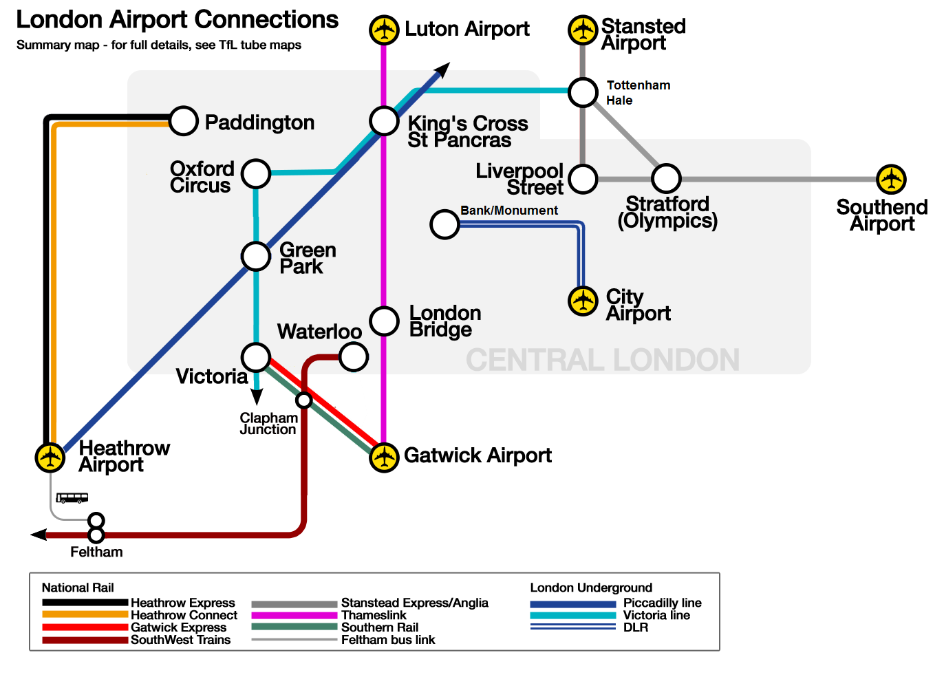
The access to London airports: London Heathrow (LHR), London Gatwick (LGW), London Stansted (STN), London Luton (LTN), London City (LCY), London Southend (SEN) is possible by various lines of urban and suburban trains, metro and bus lines of Greater London.
To find out how to get to central London, you will first need to choose your arrival airport:
Depending on your airport of arrival, several means of airport transfers are available to drop you off in the centre of London, close to the National Rail Service central stations and all stations are connected to the Bus network and underground stations.
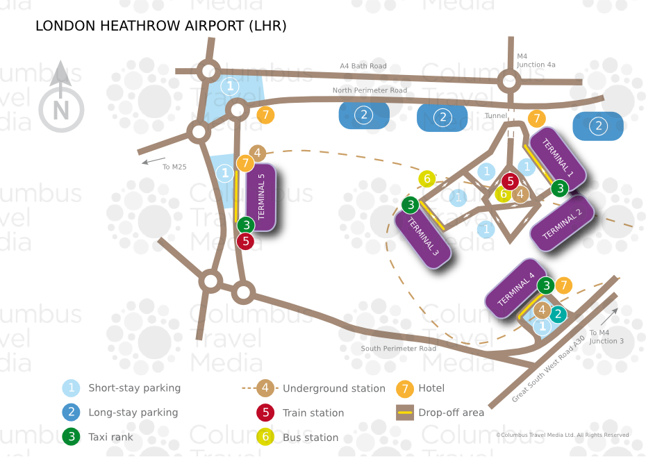
The airport of London Heathrow also known as Heathrow is the most important british airport located 13 miles (22 km) west of London. It is the most important airport in Europe for passenger traffic with 69.4 million travelers in 2011. It has 4 terminals which are terminal A, terminal B, terminal C and terminal D.
Several means of transport are available to reach central London from Heathrow Airport:
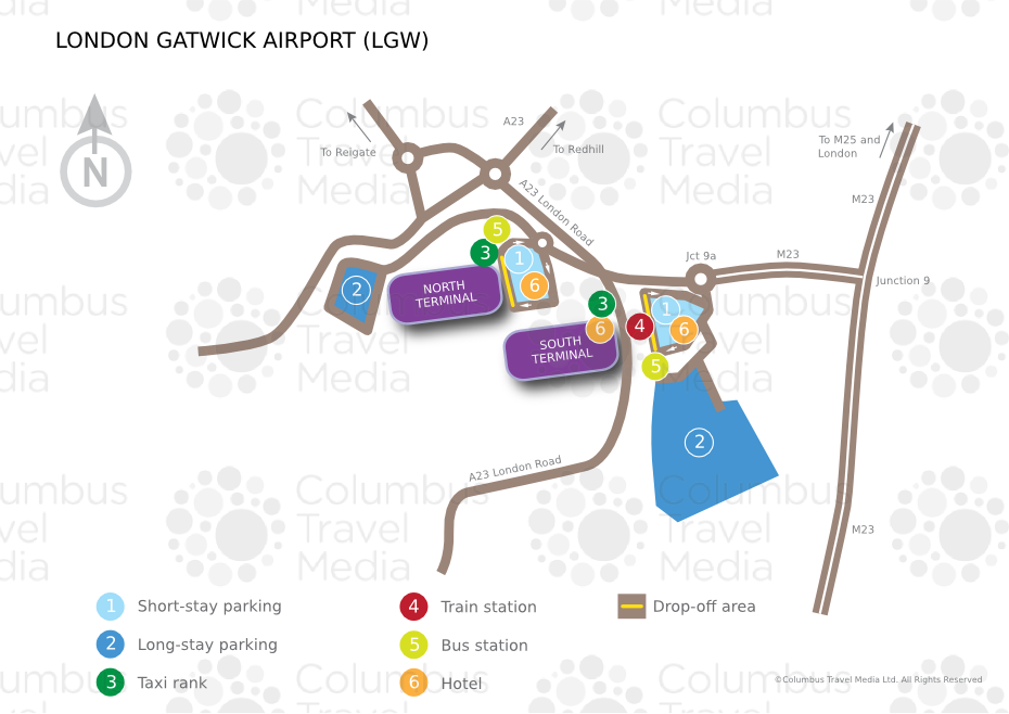
The airport of London Gatwick also known as Gatwick is the 2nd most important british airport located 27 miles (45 km) south of London. It is the 24th largest airport in the world for passenger traffic with 34 million travelers in 2009. It has 2 terminals which are north terminal north and south terminal.
There are several means of transport available to reach central London from Gatwick Airport.
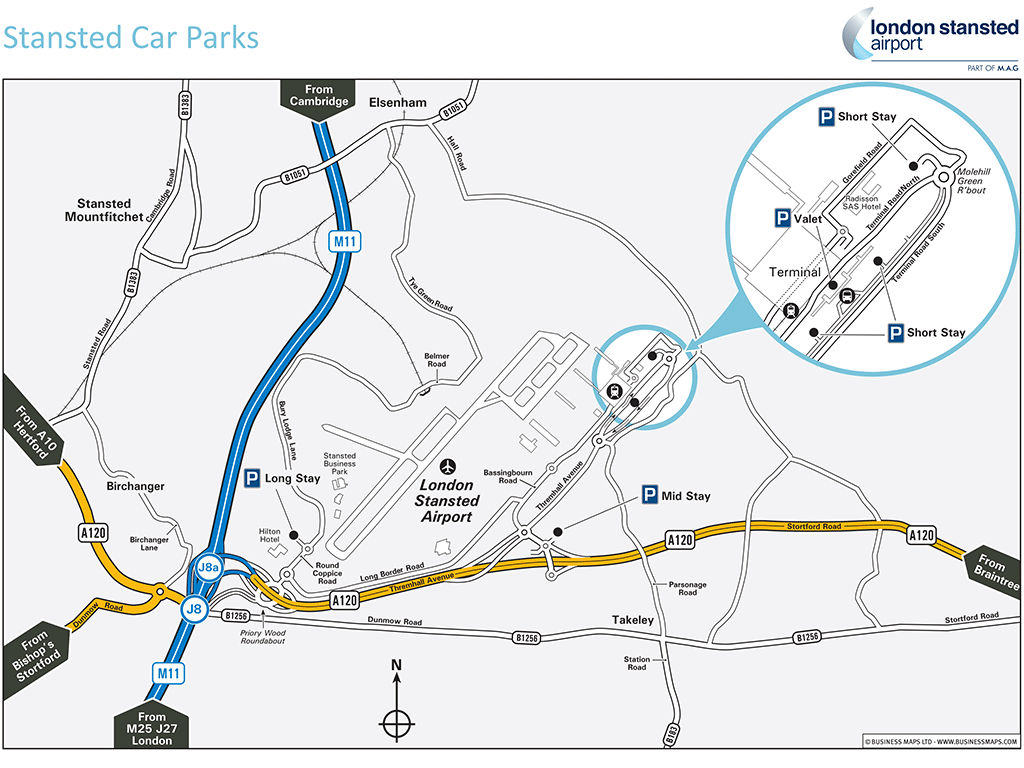
The airport of London Stansted also known as Stansted is a british airport located 29 miles (48 km) north east of London. It is the 3rd airport of London for passenger traffic with 17.8 million travelers in 2009. It has 2 terminals which are north terminal and south terminal.
To reach London from Stansted Airport, you can use one of these means of transport:
The Stansted Express train runs to central London to Liverpool Street Station and Tottenham Hale Station with a departure every 15-30 minutes and a journey time of approximately 50 minutes. One adult ticket is approximately £23.40 one way, .
National Express Buses leave Stansted Airport to Victoria Station in central London in up to 1.5 hours. Allow approximately £12 one way for an adult ticket with a departure every 30 minutes.
A private transfer (maximum 8 people) can be an economical choice.
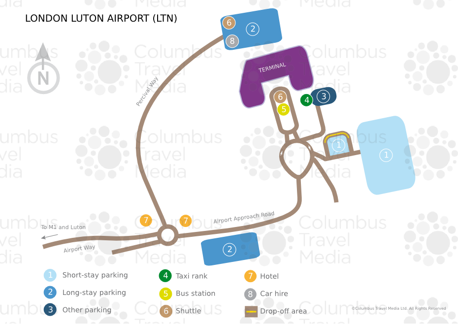
The airport of London Luton also known as Luton is a british airport located 27 miles (45 km) north west of London. It is the 4th airport of London for passenger traffic with 9.7 million travelers in 2013. It has a unique terminal.
From Luton Airport you can reach the centre of London by various means of transport:
By Thameslink train: Luton Airport is connected to Luton railway station. On arrival at the airport, you will need to take a shuttle bus (free of charge) outside the terminal at stop number 1 which will drop you off at Luton Airport Parkway station. Thameslink will take you in central London to King Cross Saint Pancras Station in one hour for £26.
National Express Buses run from Luton Airport to Victoria Station in central London in one hour and twenty minutes for £26.
£8 (one way for an adult ticket).
Private transfer is possible especially if you travel in a group (maximum 8 people).
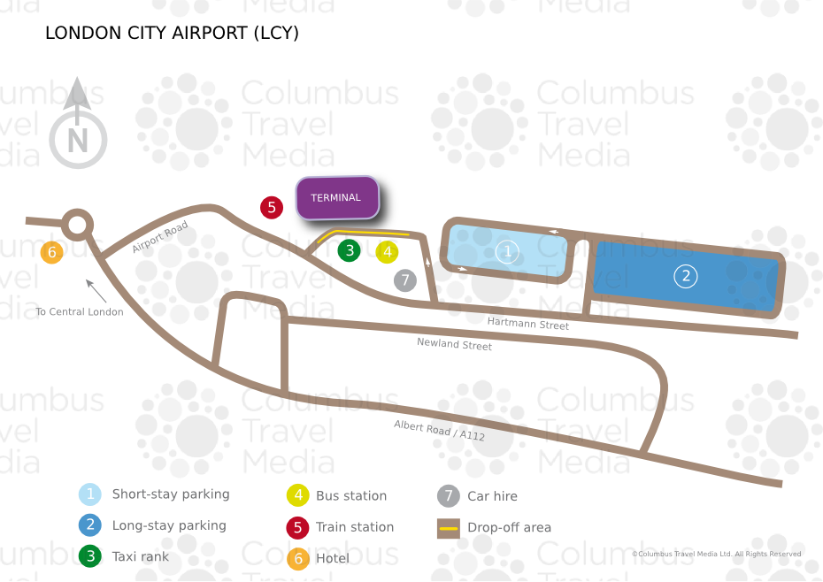
The airport of London City also known as LCY is the 15th largest british airport for passenger traffic with 3.3 million travelers in 2013. It has a unique terminal.
Here are the means of transport available to connect London from London City Airport :
The DLR (the Docklands Light Railway) from London City Airport station to the :
You can also book a vehicle with a capacity of three, five or eight people. The more people you have, the more financially attractive it will be.
The airport of London Southend also known as Southend is a british airport located 37 miles (58 km) east of London. It is the 6th airport of London for passenger traffic with 970,000 travelers in 2013. It has a unique terminal.
The quickest and easiest way to reach London from Southend Airport is by train. Southend Airport train station is connected to Southend Airport. The Greater Anglia train will take you in the centre of London to Liverpool Street station in about 53 minutes or to Stratford station in 44 minutes. Count around £15 for a single journey ticket (Please note that the OysterCard is not valid from Southend).


